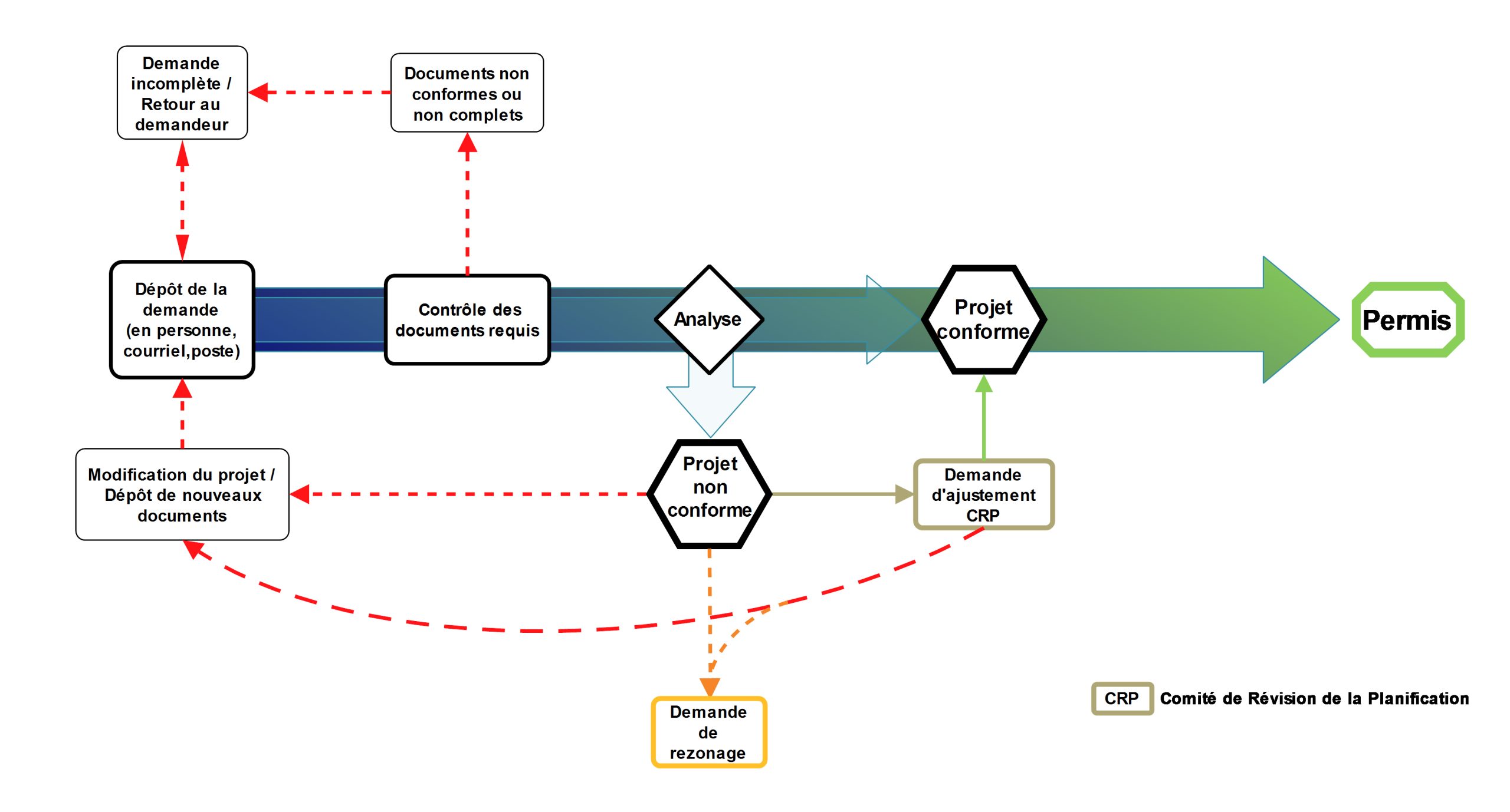
You don’t need to obtain a development/building permit if the work involves:
However, please note that specific National Building Code (NBC) standards may apply to certain types of work (e.g. insulation thickness), depending on the type of product used. For further information, please contact one of our building inspectors. However, in the Town of Caraquet, some types of work that do not require a building permit must be approved by the heritage preservation committee. Please contact the municipal administrative offices for further information.
By definition, any type of work not included in the above list. Provincial Building Regulation 2002-45 or the building by-law in your municipality requires a permit for any construction, demolition, renovation, modification, installation, replacement or change of use. Here is a non-exhaustive list of projects requiring the issuance of a permit before work can begin:
Yes, whether the pool is in-ground, above ground or inflated, it must have an enclosure, so a permit is required. Swimming pools are regulated across the province of New Brunswick; the regulations vary from one LSD and municipality to another. The enclosure permit is used to verify that your project meets minimum safety standards and is designed to protect your family from drowning.

Yes, if you have the required skills and are familiar with the National Building Code. Although professional certification is not required, you are advised to contact a certified engineering technologist (C.E.T. or P.Tech.) to help you with your project. Under section 2.2.2 of the National Building Code, the inspector reserves the right to accept or reject your building plans. The plans for a new home or an extension of more than 50% must include the following:
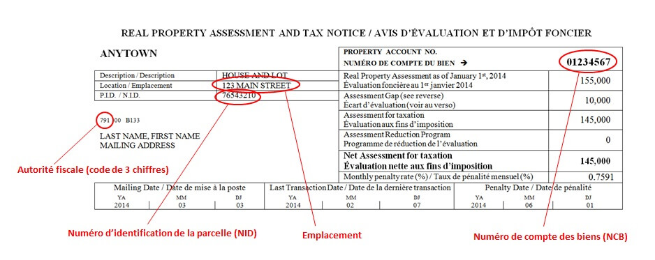
In order to identify the owner and the lot covered by the permit application. If the applicant is not the owner, an authorization (proxy) is required. All permit applications must include the address and the parcel identifier (PID) for the lot, which are indicated on the property tax notice.
The PID designates the identification number for a given lot (it stands for “parcel identifier”). This eight-digit number is assigned to your property so it can be located on a map. The PID is found in the upper left-hand corner of the assessment and tax notice. A sample notice is provided below.

An implementation plan shows the position and dimensions of building structures in relation to the lot, as well as to any watercourses or wetlands. This plan includes the dimensions of the lot, the existing and proposed dimensions of the primary building structure (e.g. house) and any accessory structures (garage, shed, patio, etc.) and the distances of the building structures from the boundaries of the property and from any watercourses or wetlands. This plan is required for certain residential projects and is used to verify that the project is in compliance with the zoning by-law. The plan may be hand-drawn by the owner but the measurements must be exact.
The cost depends on the estimated value of the work to be performed and on fees determined by regulation. This rate varies from one LSD or municipality to another. For further information, please consult the document entitled “Fees“.
A detailed site plan shows the position and dimensions of the various building structures and developments in relation to the lot, as well as to any watercourses or wetlands. This plan also shows the use of the yard areas and includes the following:
Site plans are mainly required for multi-family residential projects, as well as for commercial and industrial projects; they may also be required for other projects. Site plans are used to verify that projects are in compliance with the zoning by-law and the National Building Code. The plan must be drawn to scale and the measurements must be exact.
Examples of plans
In LSDs, all work performed less than 30m (100’) from the right-of-way of a provincial road requires a certificate establishing the setback (issued by the New Brunswick Department of Transportation and Infrastructure). This certificate is required under the provincial setback regulation in order to prevent roadside obstruction and to ensure safety. A certificate application must be submitted by contacting the regional office of the Department of Transportation and Infrastructure.
For any modifications to lot boundaries, the services of a surveyor must be obtained. Feel free to come in and consult one of our agents for preliminary information on your project or you may choose to do business directly with the surveyor. Once the ground surveys have been completed, the surveyor will submit an official subdivision application for approval by our office, as required under New Brunswick’s Community Planning Act. Once the final plan has been signed and approved, all you have to do is register it at the Service New Brunswick regional office for it to go into effect.
It is not possible to divide a lot that includes a right of way. Under the provincial subdivision regulation, all lots must be created on a public road or another access road regulated by a policy issued by the Commission (CSRPA). A right of way is not regarded as another access road by the CSRPA.
You only have to have a lot surveyed if you are selling or transferring a portion thereof. If you transfer or sell the entire lot, you are not required to have it surveyed under New Brunswick legislation. However, it is important to keep in mind that only a survey map and a surveyor can legally certify the lot’s dimensions and locate the property boundaries.
Whenever building or property use is involved, the development officer must refer to the local community planning regulations. On the Acadian Peninsula, there are 14 municipalities, each of which has its own regulations, in addition to 11 LSDs governed by a rural plan (departmental regulations) and 24 LSDs governed exclusively by provincial regulations. Consequently, it is essential to accurately define the lot being used for the project and then refer to the applicable regulations.
A waiver is a reasonable adjustment to a regulation or an exemption from complying with one or more provisions of a zoning or subdivision by-law. This procedure is used to adapt a regulation to a particular situation. The adjustment application must meet various analytical criteria and must be reasonable and justified. A waiver cannot involve land use.
A complaint can be filed at your municipal office or with the CSRPA’s community planning department. A form must be filled out and must include the complainant’s name and telephone number. The complainant’s personal information is kept confidential. The rest of the complaint may be disclosed if necessary.
Whenever building or property use is involved, the development officer must refer to the local community planning regulations. On the Acadian Peninsula, there are 14 municipalities, each of which has its own regulations, in addition to 11 LSDs governed by a rural plan (departmental regulations) and 24 LSDs governed exclusively by provincial regulations. Consequently, it is essential to accurately define the lot being used for the project and then refer to the applicable regulations.
Whenever building or property use is involved, the development officer must refer to the local community planning regulations. On the Acadian Peninsula, there are 14 municipalities, each of which has its own regulations, in addition to 11 LSDs governed by a rural plan (departmental regulations) and 24 LSDs governed exclusively by provincial regulations. Consequently, it is essential to accurately define the lot being used for the project and then refer to the applicable regulations.
Whenever building or property use is involved, the development officer must refer to the local community planning regulations. On the Acadian Peninsula, there are 14 municipalities, each of which has its own regulations, in addition to 11 LSDs governed by a rural plan (departmental regulations) and 24 LSDs governed exclusively by provincial regulations. Consequently, it is essential to accurately define the lot being used for the project and then refer to the applicable regulations.
The Service New Brunswick regional office is the place to go for information on property titles (deeds) and property taxes. All information on record is public, so all you have to do is submit an application. This service is also available online using the “Planet” system (available by subscription only).
The Service New Brunswick regional office is the place to go for information on property titles (deeds) and property taxes. All information on record is public, so all you have to do is submit an application. This service is also available online using the “Planet” system (available by subscription only).
The Service New Brunswick regional office is the place to go for information on property titles (deeds) and property taxes. All information on record is public, so all you have to do is submit an application. This service is also available online using the “Planet” systems (subscription only).
A surveyor is the appropriate person to answer this question.
This is a local authority responsibility. If you are in a municipality, please contact the municipal administrative office. If you live in an LSD, please contact the regional office of the New Brunswick Department of Transportation and Infrastructure.
A surveyor is the appropriate person to answer this question.
A surveyor is the appropriate person to answer this question.
Nouveau plan municipal et arrêté de zonage pour la ville de Caraquet